6. Fiske Peak
The rapids of Cache Creek are more blue-green than brown as they were the last time I stood on the bridge connecting Cache Creek Canyon Regional Park to the system of trails on "Road 40," which isn't really a road at all anymore. The water gauge reads just below 3.5 feet today, but it still looks too swift to step foot in. It's breezy and cool. In a spur of the moment decision, I'd chosen to wear shorts instead of my customary pants, made of a remarkably durable synthetic fabric I'd once caught on barbed wire and managed not to tear. It's good to feel the breeze on flesh. But I regret the decision anyway: what if I get into a pinch with some poison oak or catch too much sun on my thighs and calves? Well, too late.
I hurry across the bridge, the usual anticipation of time and distance and water and calories on my mind. How long will it take me to reach the summit? Will I have enough water? Will I make it home before dinner? Will the sandwich I'd grabbed out of the cool case in the supermarket be enough?
A Sierra writer whose trip reports I admire describes this feeling as the “off-gassing” of daily life, the psyche sloughing off the everyday pressures that way on us.
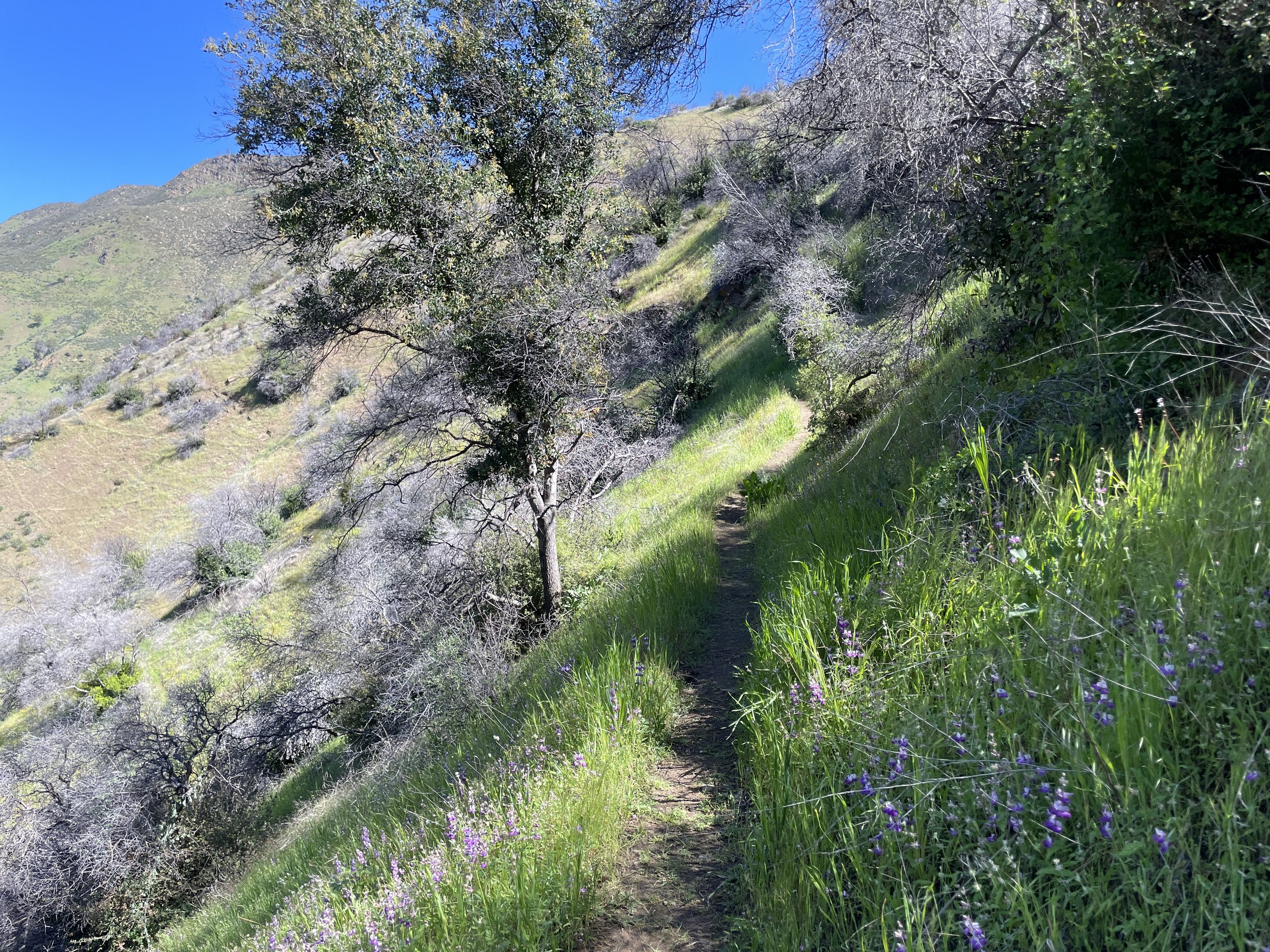
The grasses where the trail meets the road are bright green. Everything is bright green in fact, except for the wildflowers and the redbuds, which are at the peak of their vibrancy and mid-transformation into the red-green leaves they'll carry for the season. Poppies and Purple and White Chinese Houses–a suspect name, as with many of California’s flowers– pop up at the trail junction, and I spring off down the trail, pushing with my trekking poles at my heels. Below me, where Cache Creek splashes up and over rocks, tall lupine, one of the best wildflowers out there, burst out of the green grass. Along the banks of the creek is a dusty pink shrub, an invasive in fact, that evidently likes water. It wreathes both sides of the creek as far as I can see.
I'd chosen this trailhead because of the ease the bridge affords in crossing Cache Creek. Getting across the usually trivial Bear Creek was more of a production than I'd hoped on my last trip. Though the height of the water has been falling steadily this spring, intermittent rainstorms--the most recent of which blew through on Friday--continue to bump up the height and velocity of the water.
From the map, it's easy to miss how cleverly constructed this trail is. It picks its way through deep brush, traversing drainages and contouring around the most difficult topographic features. At some points, it clings precariously to the loose slope.
At the signed trailhead, where it splits off from the old Road 40, is a posted sign about the threat of mosquitoes and ticks. Yikes--hailing from the east coast, I always forget that ticks are also a concern here. In Tennessee, once, my party finished a day hike with dozens of crawling on us. You could see them dropping off the trees looking for their next lunch.
I look at my bare legs and shudder again. Why did I choose shorts today? By day's end, I'll surely be burnt, tick-ridden, and covered in poison oak.
The trail begins in a lushly wooded and shady canyon. On this above average snow year, the water is running clear three or four inches deep through the streambed. Though I'm carrying two liters of water, it would make a suitable source for a portable filter. Fiddlenecks, with their curved green stalks and delicate yellow flowers reach into the trail and brush against my ankles. On the sunnier slopes are abundant blue dicks, with their clusters of purple flowers, and Purple Chinese Houses, with their pleasant, symmetrical arrangements of magenta and white petals that create a kind of four-sided tower.
At first, the trail is tightly wooded, ambling along the creek. Scrub oaks and gray pines reach over the trail to cast their shadows, andgrowing waist-high is leather oak, madron, and toyon, with their waxy green leaves. In their midst, though, are tall bunches of poison oak, their shiny red-green leaves of three easy to spot but sometimes hard to dodge, crowding into similar shrubs and breaching the borders of the trails. This would become a pattern on this hike, as it did last fall in Stebbins Cold Canyon: keeping a watchful eye for where poison oak reaches into the trail and carefully dancing around it.
After finding its way up this creek, the trail crosses the stream and reverses back, wrapping its way around a small ridge. On this section, the sun-drenched hills burst with the oranges and golds of poppies and fiddlenecks. I stop to admire this sight--this is one of the true pleasures of hiking California's foothills in the springtime. Abundant green grasses, cooling breezes, warming sun. As a bonus, in these dryer, more exposed sections, the poison oak falls to a minimum.
I stoop over to examine the shape of a poppy. Mark Twain once compared the richness of a poppy's color to pure, melted gold. The flowers typically have three or four long, curved petals that tighten up when the arm is cool and open fully when it warms up. When it's chillier, like it was this morning, the petals form a kind of bulb shape, like a tulip. Looking down into the flower, the petals cast faint shadows limned with a brightening gold. Their effect is mesmerizing, a whorl of gold with finely kept edges.
In the shrubby vegetation along the trail climbs a vine I've not noticed before. It has wide, veined leaves, and creamy white flowers with four petals. Pipestem clematis, or chapparal clematis, as it seems to be known by nurseries. It's a lovely climbing vine for the native plant gardener to consider.
On a break, I consult the map. The contour I'm on wraps around the hard edge of the ridge, keeping to the north side of the slope until I turn the corner, when I'll find myself on a more east-facing slope. It makes sense, then, that I've found such a lush, early Spring sight, tucked into the shaded, moist north face. Every few feet, I stop to scan a new flower with Seek, a naturalist phone app that uses machine learning to identify flowers. Purple Chinese Houses, fiddleneck, Blue Dicks, Cardinal Catchfly, Paintbrush, Red Larkspur, Maidenhair Fern, the ominously named Fremonth's Death Camas, Phlox-leaved Bedstraw, Pitcher Sage, Popcornflower--the hillside is bursting with these flowers, the best time of year to hike in California.
Then the trail rises and curves around the edge of the ridge, and it's as if I've been transported to the high desert, with rocky escarpments jutting up from chapparal. Far below me, Highway 16 braids itself into the curve of Cache Creek, tucking into hills and dropping out of sight to the Capay Valley.
More sparsely vegetated, with tufts of chemise growing up around burned over manzanita, I'm surprised by the starkness of the landscape. I'll find out when I get home that the ridge burned in the early aughts. Investigators determined the cause to be arson initiated--amazingly--by a longtime firefighter who had set a series of fires in the area in order to bring glory to his reputation.
Where the ridge wraps around, I find a good place to climb up on a rock and eat my sandwich. It's a stunning day, without a single cloud in the sky, warm but not hot, breezy but not windy. The view opens up far to the east, where I can see the brilliantly reflective snowcap at the peak of Mount Lassen and follow with my eyes south along the Sierra Nevada to the end of the Crystal Range above Sacramento.
Above me, two ravens perform aerial maneuvers, diving and swirling around each other and making their distinctive sounds, a low bleating. Watching them, I listen more intently to the sounds of other birds. The chittering sounds of a Bell’s Sparrow and a Dark-eyed Junco, the jaunty singsong of a Bewick’s Wren. The overlapping sounds create an auditory weave, a kind of fabric in the air that in its own strange way becomes imbued with the feeling of air itself. The feeling of wind–of pressures balancing in the atmosphere and exerting themselves–is also the sound of wind and of the animals that fly in wind the way fish swim in water. And the sound of manzanita leaves flicking rapidfire in the wind, of chemise batting itself around, of oak leaves rustling together. This is air, all of it.
The sunlight, the breeze, the air, I let it all wash over me.
Rising to move on from my resting place, I follow the trail as it behaves in this more desertlike manner. I feel buoyant and fast, cruising up the path higher and closer to the crest.
Wilted tufts of Warrior’s Plume are nestled along the trailside, already past their peak and faded since I saw them first poking out of the soil in March. The speed at which Spring comes and goes is astonishing, marked by the faded petals of once vibrant flowers.
Once the trail reaches the summit of the crest, it’s almost a straight line south to the peak labeled Fiske Benchmark on the topo map. This is perfect terrain for a trail runner, riding right up through clean lanes of chaparral and with minimal poison oak. The view opens up to the east and to the west, and along the length of the ridge I can see Snow Mountain and lesser snowcaps of the Coastal Range, right up to the impressive conical peak of Mount Shasta, capping the northern terminus of the Sacramento Valley. From there, the snowy high country of Lassen and Plumas wreath the horizon, all the way down to the pass below Echo Summit in South Lake Tahoe.
At the peak, I find an old peak register that could use replacing. Regardless, this is one of the purest pleasures of hiking–arriving at a high peak and unpacking the various makeshift canisters other hikers have used to store notebooks, pens, pads of paper, loose sheets, and messages to other hikers. I sign and date the register book. Just below the peak, I notice a deep depression still wet from a recent rain. It’s obvious all the rain that falls on this peak runs off into this low spot.
The other peaks around me are draped with fire roads. From afar they look like veins in the hills–good paths for humans and animals to follow, but a sobering reminder of intensifying wildfire cycles in California.
In the fall of 2022, just before a historic drought-busting winter, I bought a cord of wood from a seller in Stonyford, an overlooked foothill hamlet on the western Sacramento Valley. After he lowered his dumper and scooped all the wood out, we chatted about his work during the summers as a bulldozer operator for CalFire and the Forest Service.
It’s kind of crazy, he told me. They pay me to go up there and destroy the land.
He shrugged.
I mean, it’s kind of fun, he said, but it’s bad. Just tearing everything up.
He must have stayed out of work for the 2023 fire season, but 2024 remains to be seen under heavy fuel loading and the knock-on effects of an El Nino cycle.
Somewhat less careful than I’d been on the way up, I cruise down the trail again, enjoying those sparse, sun-soaked hillsides with their explosions of tiny colorful petals, and stepping quickly past the bunches of poison oak crowding the trail, back to the turgid waters of Cache Creek.